Powered by FAST3DIS™ 3D Perception AI
FAST3DIS™ Edge
3D Human Tracking at the Edge

Privacy-first, real-time 3D human detection, tracking, and analytics — deployed on-premise with multi-LiDARs fusion.

FAST3DIS Edge — Real-time multi-human tracking dashboard
See It In Action
Real Software. Real Deployments.

FAST3DIS Edge ships as a complete platform — from sensor calibration to live tracking and analytics.

FAST3DIS Edge — Real-time multi-human tracking dashboard
01 — Tracking

Live Multi-Human Tracking

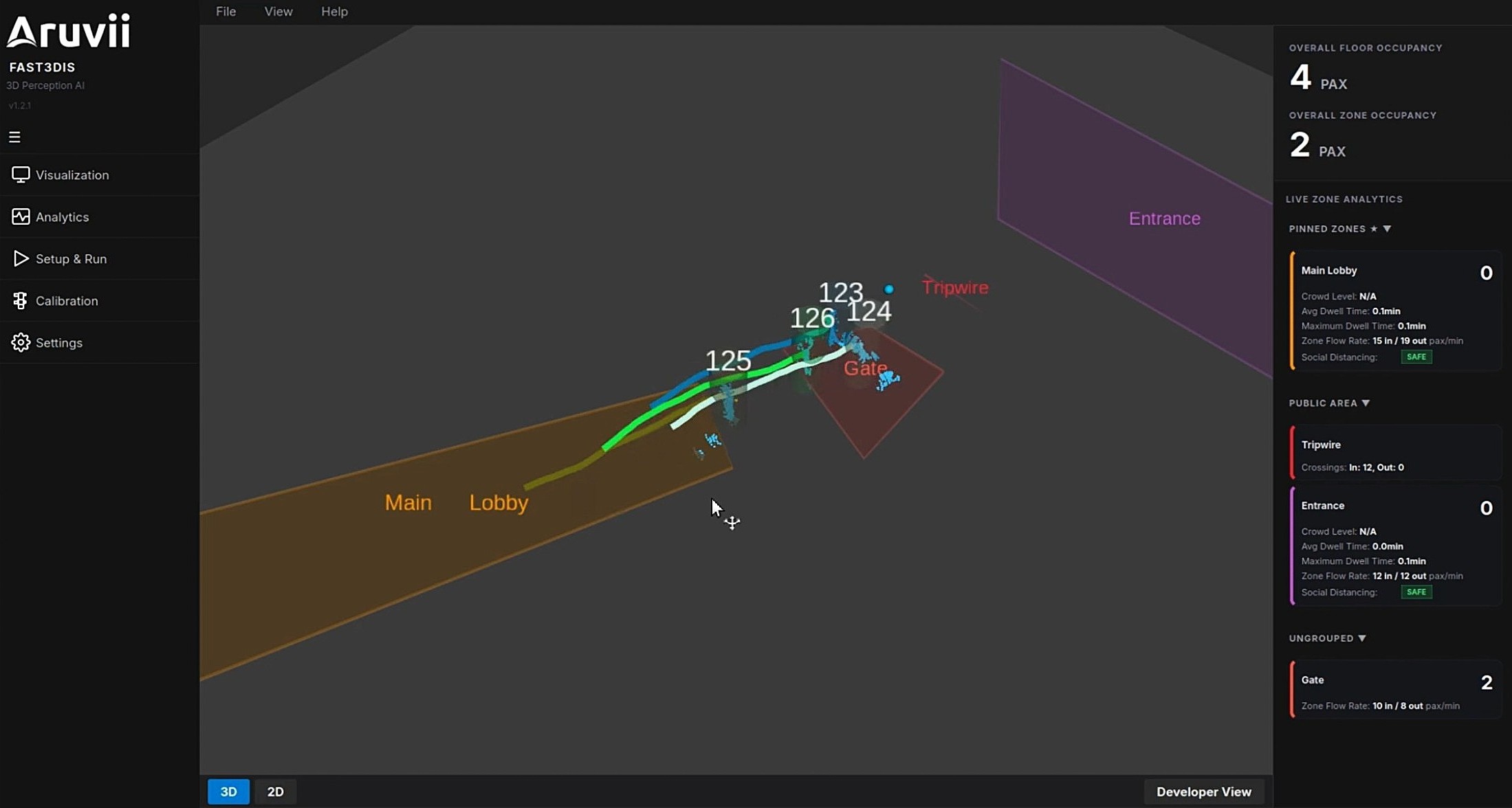
Real-time 3D view with persistent tracker IDs, trajectory trails, and live headcount — processed entirely from LiDAR point clouds at the edge.

FAST3DIS Edge — Live zone analytics with polygonal zones and tripwires
02 — Analytics

Live Zone Analytics

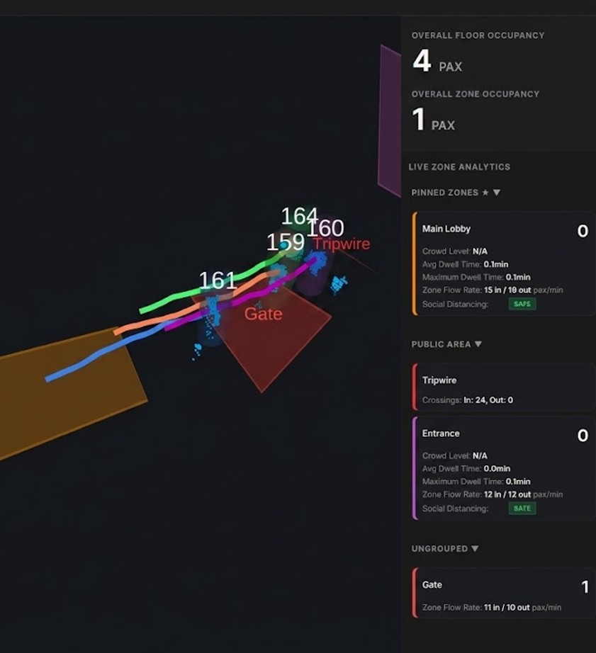
Define polygonal and tripwire zones to monitor human count, social distancing, anti-tailgating, dwell-time, crowd density, and crossing counts.

FAST3DIS Edge — Fusion calibration interface
03 — Setup

Multi-Sensor Calibration

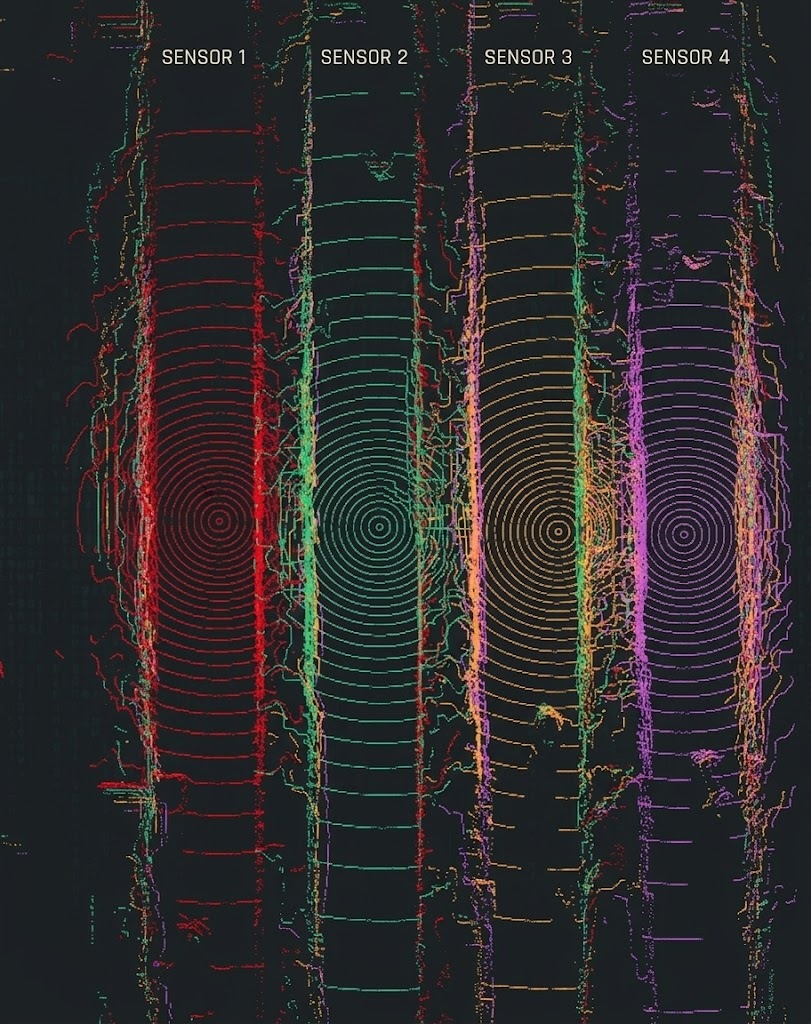
In-software fusion calibration for aligning multiple LiDAR sensors into a unified coordinate frame. Setup that once took hours now completes in minutes.

Why FAST3DIS Edge
Enterprise-Grade by Design

Purpose-built for system integrators and enterprise deployments that demand reliability at scale.

< 100ms

Sub-Second Latency

Real-time processing at the edge — detection to metadata output in under 100ms per frame.

Days → Minutes

In-Built Multi-Sensor Calibration

Integrated multi-sensor calibration reduces deployment setup from hours to minutes.

10+ brands

Sensor-Agnostic

Works with LiDAR from Robosense, Ouster, Livox, Hesai, Seyond, LSlidar, OMRON, and more.

Zero cloud

Edge-Native

Runs entirely on local compute — no cloud dependency, no data leaves the premises. Full data sovereignty.

MQTT · REST

API-First Output

Structured JSON metadata via MQTT, REST — plug into any BMS, dashboard, or application.

100+ sensors

Scales to 100+ Sensors

Hierarchical node architecture designed for campus-scale and multi-building deployments.

Architecture
How It Works

Four-stage edge pipeline — from raw sensor data to actionable metadata in milliseconds.

01

3D Sensors

LiDAR, ToF, or depth sensors capture raw 3D point clouds of the monitored space.

02

Edge AI Compute

On-premise FAST3DIS engine processes point clouds in real-time using proprietary detection & tracking models.

03

Perception Metadata

Structured JSON output — positions, tracks, zone events, occupancy counts — streamed via MQTT or REST API.

04

Your Systems

Feed into BMS, HVAC, digital twins, dashboards, or any downstream application.

Applications
Built for Real-World Deployments

Purpose-built for environments where privacy, accuracy, and real-time performance are non-negotiable.

Smart Buildings & Offices

Real-time occupancy sensing for HVAC optimization, space utilization analytics, and meeting room management — without cameras invading workspace privacy.

Occupancy Energy Savings Space Planning

Airports & Transit Hubs

Queue detection, gate area crowd density, passenger flow analytics, and dwell-time monitoring across large, high-throughput environments.

Queue Management Crowd Analytics Flow Optimization

Healthcare Facilities

Patient and staff tracking in wards, waiting areas, and common spaces — fall detection alerts and compliance monitoring without capturing identifiable imagery.

Patient Safety Fall Detection Ward Monitoring

Retail Spaces

Shopper footfall, zone heatmaps, dwell-time by display area, and real-time headcount — powering store layout optimization and staffing decisions.

Footfall Heatmaps Dwell Analytics
Get Started
Ready to Deploy Spatial Intelligence?

Talk to our team about piloting FAST3DIS Edge in your environment.